


NEW DELHI, 10 June 2021: According to the National Weather Forecasting Centre of the India Meteorological Department: (Thursday 10 June 2021, MID-DAY, Time of Issue: 1345 hours IST)
Significant Weather Features
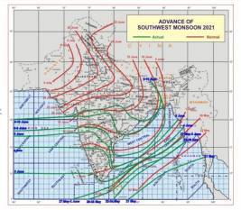
Southwest Monsoon has further advanced into some more parts of south Gujarat region, remaining parts of Maharashtra, Telangana, and Andhra Pradesh, some parts of south Madhya Pradesh, Chhattisgarh and south Odisha, remaining parts of central Bay of Bengal, and most parts of North Bay of Bengal today, the 10th June 2021.
The Northern Limit of Monsoon (NLM) passes through lat. 20.0°N/ Long. 60°E, lat. 20.5°N/ Long. 70°E, Surat, Nandurbar, Betul, Mandla, Bilaspur, Bolangir, Puri, 22.5°N/89.5°E, 24.0°N/89.5°E and Baghdogra.
Conditions are favorable for further advance of southwest monsoon into some more parts of Gujarat, Madhya Pradesh, remaining parts Chhattisgarh and Odisha, entire West Bengal and Jharkhand, and some parts of Bihar and east Uttar Pradesh and remaining parts of north Bay of Bengal during next 48 hours.
A cyclonic circulation lies over Northwest Bay of Bengal and extends up to the mid-tropospheric level. Under its influence, a Low-Pressure Area is likely to form over Northwest Bay of Bengal & the neighborhood during the next 24 hours. it is likely to become more marked during subsequent 24 hours and move west-northwestwards across Odisha.
Under its influence; fairly widespread to widespread rainfall activity with isolated to scattered heavy to very heavy falls very likely over most parts of East India & adjoining Central India from today. Isolated extremely heavy falls (≥ 20 cm) also very likely over Odisha on 11th & 12th; over Chhattisgarh during 11th-13th; over East Madhya Pradesh on 13th; over Vidarbha on 12th & 13th, June 2021.
Due to the strengthening of westerly winds along the west coast in association with Low-Pressure area; widespread rainfall activity with heavy to very heavy falls likely to continue over coastal districts of Maharashtra during 10th to 15th June and likely over coastal
Karnataka during 12th to 15th June, 2021. Isolated heavy rainfall is very likely over Kerala during 12th to 15th June 2021.
Isolated extremely heavy falls also very likely over Konkan during 12th to 15th June 2021.
Due to the west-north-westwards of the Low-Pressure area & its remnant, fairly widespread to widespread rainfall activity with isolated heavy falls is very likely over northwest India (excluding Rajasthan) during 12th to 14th June 2021. Isolated very heavy rainfall also very likely over Uttarakhand and Uttar Pradesh on 12th June.
Ahead of the monsoon onset, fairly widespread thunderstorm activity accompanied by frequent cloud to ground lightning is likely over Madhya Pradesh, Uttar Pradesh, Uttarakhand, Chhattisgarh,
Odisha, Bengal, Jharkhand, and Bihar during the next 2 days.
Heatwave conditions very likely in isolated pockets over south Haryana on 10th and over Northwest Rajasthan on 10th & 11th June.