


NEW DELHI, 14 June 2020: According to the National Weather Forecasting Centre/Regional Meteorology Centre, New Delhi of the India Meteorological Department.
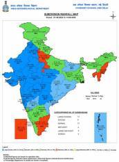
Advance of Southwest Monsoon till 14 June 2020
- The Southwest Monsoon has further advanced into remaining parts of Central Arabian Sea,some parts of northeast Arabian Sea, Gujarat state, Dadra & Nagar Haveli, remaining partsof Maharashtra (including Mumbai), some parts of Madhya Pradesh, most parts ofChhattisgarh and Jharkhand and some more parts of Bihar.
- The Northern Limit of Monsoon (NLM) now passes through Lat.20°N/Long.60°E,Lat.20°N/Long.70°E, Surat, Nandurbar, Betul, Seoni, Pendra Road, Ambikapur, Gaya,Patna and Lat.27°N/Long.85°E.
- The Chief amount of rainfall (in cm) more realized past during 24-hours till 0830 IST of14th June 2020 (>5cm):
Gujarat: Madhbun (Dadara & Nagar Haveli)-9, Abad City (Ahmedabad)-7, Dahegam(Gandhinagar)-7, Nanipalson (Valsad)-7, Gandhinagar (Gandhinagar)-6, Talod(Sabarkantha)-6, Khanvel (Dadara & Nagar Haveli)-6, Kaprada (Valsad)-5, Malpur (Aravalli)-5, Nakhatrana (Kutch)- 5 cm
Maharashtra: Mumbai(Colaba)-1, Mumbai (Santacruz)-2, Pernem (North Goa)-12,Mokheda (Palghar)- 12, Matheran (Raigad)- 8, Malvan (Sindhudurg)- 7, Ulhasnagar(Thane)- 11, Amalner (Jalgaon)- 6, Shahada (Nandurbar)- 7, Igatpuri (Nashik)- 7, Ashti
(Beed)- 5 and Aundha Nagnath (Hingoli)- 7
Southwest Monsoon till 14 June 2020
For the country as a whole, Seasonal cumulative rainfall during this year’s southwest
monsoon till 14th June 2020 is above Long Period Average (LPA) by 31%. It is 19 percent, 94 percent & 20 percent above their LPA over northwest, central & south peninsular Indiarespectively. Details of the rainfall distribution over the four broad geographical regionsof India are given below:
Regions Actual Rainfall (mm) Normal Rainfall (mm) Departure from LPA
Country as a whole 75.8 57.8 31 percent
Northwest India 27.2 22.8 19 percent
Central India 91.0 46.9 94 percent
South Peninsula 80.2 66.9 20 percent
East & northeast India 131.8 137.4 -4 percent
Meteorological Conditions
- A trough runs from northwest Rajasthan to coastal Odisha at lower tropospheric levels.
- An east-west shear zone runs along Lat.22°N across Central India between 3.1 and 4.5 kmabove mean sea level.
- A cyclonic circulation lies over East Madhya Pradesh & neighbourhood at mid-troposphericlevels.
Forecast & warnings
- Under the influence of above systems, conditions are becoming favourable for furtheradvance of Southwest Monsoon into some more parts of North Arabian Sea, Gujaratand Madhya Pradesh, remaining parts of Chhattisgarh, Jharkhand and Bihar andsome parts of East Uttar Pradesh during next 48 hours.
- Fairly widespread to widespread rainfall very likely to continue over Maharashtra, Gujarat,most parts of central and east India during next 4-5 days with isolated heavy to veryheavy falls over Konkan & Goa, Madhya Maharashtra, Gujarat and isolated heavy oversouth Madhya Pradesh, Vidarbha, Chhattisgarh and Marathwada during next 2-3 days.