


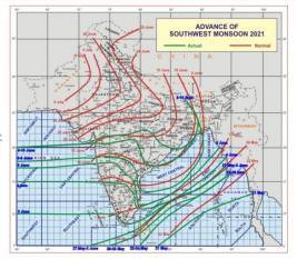


NEW DELHI, 15 June 2021 : strong>NEW DELHI, 15 JUN 2021: According to the National Weather Forecasting Centre of the India Meteorological Department (IMD). The Northern Limit of Monsoon (NLM) continues to pass through 20.5°N/ Long. 60°E, Diu, Surat, Nandurbar, Bhopal, Nowgong, Hamirpur, Barabanki, Bareilly, Saharanpur, Ambala, and Amritsar.
Due to the approaching mid-latitude westerlies winds, further progress of monsoon over remaining parts of northwest India is likely to be in the progress of monsoon which is being monitored continuously and a further update will be provided on daily basis.
The Low-Pressure Area lies over east Uttar Pradesh and adjoining Bihar and associated cyclonic circulation extends up to mid-tropospheric
The trough at mean sea level runs from Northwest Rajasthan to northwest Bay of Bengal across Haryana, Southwest Uttar Pradesh, the center of a low-pressure area over east Uttar Pradesh and adjoining Bihar, Jharkhand, Gangetic West Bengal and extends up to 9 km above mean sea level.
Under the influence of the above systems
Fairly widespread to widespread rainfall with isolated thunderstorm & lightning over most parts of East, Central, and Northeast India during next 4-5 Isolated heavy rainfall over the region during next three days and isolated extremely heavy falls also very likely over Bihar on 15th June.
Scattered to fairly widespread rainfall with isolated thunderstorm and lightning over most parts of Northwest India during next two days and decrease in rainfall activity thereafter except East Uttar Pradesh were fairly widespread to widespread rainfall is likely to continue during next 4-5 days. Isolated heavy to very heavy rainfall over East Uttar Pradesh during next five days and extremely heavy rainfall also very likely over East Uttar Pradesh on 15th June.
An offshore trough runs from North Maharashtra coast to North Kerala coast, under its influence Widespread rainfall with isolated heavy to very heavy falls, thunderstorm and lightning are very likely over south Konkan and Goa, Karnataka, and Kerala and Mahe during next 3.
Moderate to severe thunderstorms accompanied by frequent cloud to ground lightning and strong gusty winds very likely over Uttarakhand, Uttar Pradesh, Madhya Pradesh, Bihar, Punjab, and Haryana, Chandigarh & Delhi on 15th June. This may cause injuries leading to casualties to people and animals staying outdoors.